- An outbreak of tornadoes is expected in the southern Plains through tonight.
- Strong tornadoes are possible from western portions of Texas into western and central Oklahoma.
- A major threat of flash flooding is expected from northwest Texas into Oklahoma, Kansas, western Missouri and northwest Arkansas.
- The storms will also generate destructive hail and high winds.
A tornado outbreak is expected to hammer the southern Plains through Monday night, along with a major risk of flash flooding, both of which will pose a serious threat to life and property.
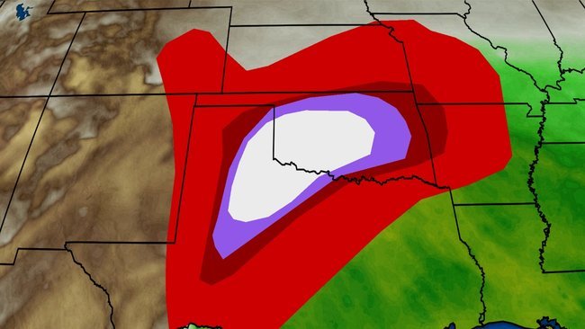
NOAA’s Storm Prediction Center (SPC) has issued a rare “high risk” of severe weather from northwest Texas into western and central Oklahoma where there is the greatest chance of strong and long-track tornadoes on Monday afternoon and evening. This highest threat level of severe weather was last issued by SPC just over two years ago on May 18, 2017.
(MORE: What a ‘High Risk’ Means)
As noted by Rick Smith, Warning Coordination Meteorologists at the National Weather Service office in Norman, Oklahoma, this will be a prolonged “onslaught of severe storms, flooding and tornadoes” in parts of Oklahoma and Texas.
Happening Now
NOAA’s Storm Prediction Center has issued the following watch areas:
-A tornado watch is in effect until 8 p.m. CDT for parts of West Texas, including Abilene, Amarillo, Childress and Lubbock.
-A second tornado watch is in effect until 10 p.m. CDT for much of western and central Oklahoma and far northwest Texas. This includes Oklahoma City, Tulsa and Wichita Falls.
-These watches are both “particularly dangerous situation” tornado watches, meaning there is a high risk of strong tornadoes.
Current Radar, Watches and Warnings
(Watches and warnings are issued by the National Weather Service.)
Monday afternoon and overnight will have the greatest threat of tornadoes and flash flooding. The potential for severe weather will also continue into Tuesday across parts of the Midwest and South.
Monday’s Forecast
Severe Threat
Strong and long-track tornadoes are most likely from northwest Texas into western and central Oklahoma through Monday night, potentially including the Oklahoma City metro area. That said, a much larger corridor from West Texas northeastward across Oklahoma into Kansas, northwest Arkansas and southwest Missouri will also have a risk of tornadoes. Destructive hail and damaging winds are likely to affect much of this same general region.
(MORE: It’s the Most Favorable Time of Year For Violent Tornadoes in the U.S.)
Monday’s Severe Thunderstorm Forecast
(Shaded on the map above is the likelihood of severe thunderstorms, according to NOAA’s Storm Prediction Center. Note that not all categories apply for the severe weather risk on a particular day.)
Flash Flood Threat
Flash flooding is also a major danger through Monday night from northwest Texas across Oklahoma into parts of Kansas, western Missouri, northwest Arkansas and southeast Nebraska.
A “high risk” of flash flooding has been issued by NOAA’s Weather Prediction Center for central and eastern Oklahoma, including the Oklahoma City and Tulsa metro areas, and southeast Kansas where travel is discouraged later today and overnight.
Rainfall totals of 3 to 6 inches are likely in a short amount of time across parts of this region by early Tuesday morning. Locally heavier totals topping 6 inches are possible in spots.
It is entirely possible that tornadoes and other forms of severe weather may occur in flooded areas. If this occurs, move to the lowest dry floor of your home or other sturdy structure.
(MORE: What to Do When Flash Flood and Tornado Warnings are Issued at the Same Time)
Flash Flood Watches and Warnings
(From the National Weather Service.)
Timing
Numerous supercell thunderstorms will erupt over the eastern Texas panhandle and Oklahoma through Monday evening. These storms will be capable of producing strong tornadoes, along with large hail and destructive straight-line thunderstorm winds.
Severe thunderstorms and flooding rain will persist into the overnight hours from northwest Texas into Oklahoma, parts of Kansas and western Missouri.
Tuesday’s Forecast
By Tuesday, a strong area of low pressure should be in place over the central Plains.
This will push the severe threat ahead of a cold front from parts of Iowa, Missouri and Illinois into Arkansas, eastern Oklahoma and eastern Texas.
Damaging thunderstorm winds, hail, some tornadoes and flooding rain are possible in these areas Tuesday.
Tuesday’s Severe Thunderstorm Forecast
(Shaded on the map above is the likelihood of severe thunderstorms, according to NOAA’s Storm Prediction Center. Note that not all categories apply for the severe weather risk on a particular day.)
Severe Weather Recap
Sunday, May 19
Damage was reported in Ville Platte, Louisiana, early Sunday morning from a possible brief tornado. Trees were also downed by severe thunderstorm winds in East Baton Rouge, Louisiana.
Scattered severe thunderstorms Sunday afternoon and evening produced damaging winds from the southern Great Lakes and Ohio Valley to the interior Northeast. The strong wind gusts knocked down trees and power lines in parts of those regions.
Among the strongest winds was a 59-mph gust in Milwaukee Sunday afternoon. A few 60-plus-mph gusts were reported in parts of east-central Illinois, Indiana, southwestern Lower Michigan and central Pennsylvania.
Saturday, May 18
A possible tornado struck near McAlester, Oklahoma, early Saturday afternoon, downing a large tree onto a home. Significant roof damage was reported.
Storms in the Dallas/Fort Worth Metroplex produced flash flooding early Saturday. Major street flooding was reported across Interstate 30 and Montgomery in Fort Worth, where up to 3 inches of rain had fallen by midday Saturday.
One strongly rotating supercell thunderstorm raked through San Angelo, Texas, early Saturday morning, prompting staff at the National Weather Service to take shelter as the rotation appeared to pass just north of the office. It then headed into the city of San Angelo, with an estimated population of 100,000. The storm produced an EF2 tornado.
Roofs of several homes were damaged in the Dove Creek subdivision, and one building collapsed at Boys Ranch on the city’s southwestern side. Numerous homes were also damaged on the city’s northern side, according to the local fire department.
This supercell was followed by drenching rain with rainfall rates in excess of 1 inch per hour, with reports of vehicles trapped in floodwaters on Southwest Boulevard and near the Angelo State University campus, according to SanAngeloLive.com.
Another tornado tore through Abilene, Texas, early Saturday morning, damaging homes on the city’s southern side and blowing roofs off homes north of downtown. This tornado was given a preliminary EF2 rating by the National Weather Service.
A large tornado touched down a few hours later Saturday morning in Runnels County, northeast of San Angelo, and tracked into the city of Ballinger, damaging homes, the high school, a water tower and a baseball stadium, according to local law enforcement. Torrential rain then led to some flooding of homes in the town.
The tornado apparently continued into Coleman County, where a church roof was damaged in Silver Valley, about 35 miles south-southeast of Abilene, Texas.
An EF2 tornado touched down in Comanche County, Oklahoma, near Geronimo. Two homes were destroyed, and one person was injured, according to a county emergency manager.
Flooding was also a serious issue in parts of Oklahoma.
At least one vehicle stalled in high water in Oklahoma City, with water reportedly up to the vehicle’s windows. Spencer, just east of the city, reported 2.30 inches of rain by early afternoon. At least a couple of vehicles were flooded out in Lawton, Oklahoma, requiring water rescues.
Friday, May 17
There were 38 reports of tornadoes Friday, though the exact number of actual tornadoes remains unknown at this time.
A tornado touched down near the Nebraska/Kansas border, then tracked northeastward to near McCook, Nebraska, as an EF2-strength with winds up to 120 mph early Friday evening. At least one home, several grain bins and multiple outbuildings were damaged northwest of town. The supercell went on to produce a pair of EF1 tornadoes later near Farnam and near Cozad, Nebraska, on Interstate 80, producing damage near the town’s cemetery.
Another tornado damaged two homes near the towns of Bloom and Windhorst, Kansas, south and east of Dodge City. A mobile home was also overturned near Windhorst.
Hail up to 3 inches in diameter pelted Sedgwick, Colorado. Thunderstorm winds blew out a window and damaged a garage door in Schleicher County, Texas, and overturned a camping trailer, injuring one camper in Scioto County, Ohio.
Flooding was also an issue in some areas. Up to 2 feet of water flooded roads in Brookings, South Dakota, Friday night.